Thursday, 16/08/2012
- 62 A.D.


Quality moment of the day – as we were driving down highway 6 we got, not just a wave from a fellow camper van driver, but a whole salute! He must have been Scottish.


…but then we came to the following sign…


Haasta la vista, baby!
[35
years to the day since Elvis died.]

The little port of Picton houses the final
resting place of the Edwin Fox, the
last ever convict ship in operation. However, we had no time to go and see it
because first thing this morning we had to have a massive dump. Our waste tank
was full because we hadn’t been able to empty it at the previous campsite and
we could hear it sloshing around when we navigated the hairpin bends. Also, the
less powerful of the gas hobs on the stove has stopped working properly and the
blue flames come out at irregular intervals. Prior to visiting the dump
station, I took the hob off the stove and blew out all the crap that collected
beneath it, but still to no avail. If it’s still knackered when we take The
Chariot to Christchurch then I’ll just say a kiwi bird got inside during the
night and pecked at it `til it worked no more.
I hear the Olympics are finally over. Given
that I got to see the opening ceremony and about 15 minutes of highlights, I
have to say I’m glad. Sounds like they were a tremendous spectacle. Now
when we meet people and say we’re
English they’ll stop wondering why we’re in their country and not back home
watching the games! Not that the New Zealanders are anyway near as surprised to
hear our accents as the Americans were. So far we’ve only been referred to as
“poms” on one occasion, and that was by an old, angry petrol attendant who was
speaking in the third person plural. I thought only the Aussies called us by
that name, but I lives and learns.

If you head west out of Picton you travel
on Queen Charlotte Drive, a windy
coastal road that is famed for its scenic views and regular lookout points. The
35 kilometres stretch to the small town of Havelock can take half a day if you
keep getting out to take in the visual wonderment, but we only stopped off a
couple of times as we wanted to get to the town of Nelson in good time.

[You can never get enough pictures of hills
and lakes, can you!]
Nelson is apparently renowned as a vibrant
arts, crafts and festival centre with a superb climate, and by the time we
rolled up it was almost cracking the flags.
The old cinema across the road was showing Fritz Lang’s 1927 masterpiece
Metropolis, which I probably would
have gone in and watched had it been lashing it down. But as it was so nice we headed over to the
Botanical Reserve, a playing field where the country’s first ever rugby match was held in 1870. Leading up the hillside from this are several walks
that overlook the town.

The above is a kouri tree, native to NZ and
probably their equivalent of our great oak. In the Wellington museum we learnt
how there were once a million hectares of these trees across both islands, but
since the Polynesians arrived in the 1300s they were reduced by a staggering
amount to number just a few thousand hectares. Today those remaining are mostly
in protected reserves, but the one above was planted in 1951 and had its own
little fence around it.
At the top of the hill, after quite an
arduous walk, was a lookout point that claimed to be the geographical centre of
New Zealand. You can never really be sure if these claims are accurate – Dunsop
Bridge in the Forest of Bowland is allegedly the geographical centre of
the UK – but wherever it was, the views were fantastic. I’m not sure how close
Nashville was to the centre of the USA, but I doubt we’ll make it to the middle
part of Australia, though that’s a tale still to be told.


It was so much easier heading back down to
Nelson. Nelson…that’s one thing I’ve immediately noticed about the south island
– much fewer Maori place names. It certainly makes navigating a lot easier!
Okay, so we still come across the odd Motupiko and Wakapuaka, but on the whole
it’s the likes of Marybank, Redwood Valley, Foxhill and, errr, Stoke. Somewhere around here there must be a
Birkdale…
The rest of our time in Nelson passed
quickly when we got distracted by something shiny (a supermarket) and those
good old rain clouds suddenly appeared on the horizon. It was our turn for
camping out in the wild tonight, but we’d found a DOC campsite that was free,
the only facilities being a water tap and a hole in the ground for dumping in
(that is humans, not Toyotas). Given that we’d surely be the only people there,
it would still feel like camping in the wild. However, shortly after driving
out of the car park we realised that we hadn’t tightened the gas canister after
making a brew. This sits in its own little cupboard on the outside of the van
and you can technically drive with it loosened, but Mrs. Health And Safety
would go nuts if she found out. When we pulled over to get out and sort it, we
almost accidentally picked up a scruffy-looking hitch hiker with a guitar, but
fortunately we weren’t going the same way as him. In America hitching was an
absolute no-go given the amount of nutters out there carrying personal
firearms, but apparently in NZ people do it all the time in total safety. In
some towns in summer you can find people queuing up to get a ride! Anyway, taking on board a hitch hiker was not
something we planned to do. Unless they were female and a fan of Liverpool F.C.
We got to Clerk Valley just before
nightfall, but missed our DOC site, so instead we parked up in a general
recreation area – the same level of isolation, but a little closer to the road.
And, for probably the first time ever, we parked on a level piece of ground,
which meant I didn’t have to guard against my peppered steak soup slopping over
the edge of the bowl and into my lap. Speaking of which, I’ve never eaten so
much tinned meaty soup in my life – certainly keeps you warm on the cold
evenings out in the open! And we also finally got our original laptop back up
and running, so for the first time this evening we sat at our table and both
worked independently on our computers without having to huff and puff because
someone was hogging the machine and taking too long. We really are living the
dream now!

[I should point out that the glass to the
left contains white wine. It’s out of the way so it doesn’t get knocked over.]
Friday, 17/08/2012
- 63 A.D.


We got up this morning to some potentially
distressing news – Tim is thinking about taking a berocca because he can feel
“something coming on”. Due to our close living proximity, if Tim gets it, I get
it. I expect to get everything from Ghandi’s Revenge to green parrot fever when
I travel through Asia, but was hoping to get through Australasia unscathed. We
shall have to play the waiting game on this one and hope the berocca works its
magic!
So, what was on the agenda for today then?
Mostly driving, unfortunately. Due to catching the ferry a couple of days later
than planned, we had to make up some time if we were going to get as far south
as we could. Therefore we zoomed westward through the windy roads towards
Greymouth on the coast. As the forested peaks rose high above us, it felt like
we were properly entering Middle Earth, specifically…I dunno, Gondor. And we
had to stop The Chariot when, far away in the distance, we got our first
glimpse of snow…

“I am NOT going up any mountains!”
“Shut up, Pip, you go where we take you!”
Upon switching onto, ahem, Highway 69, we
came across our first livestock obstruction. The guidebook said it’s quite common
to be held up while sheep are driven across the road and I was quite looking
forward to going through the experience. On this occasion though, the blockage
was distinctly bovine in nature:


Shortly after that great thrill, we arrived
in the small town of Greymouth and parked up for a look around. Thank goodness
it was a gorgeous sunny day, because it would have been our gloomiest
experience so far if the rain had been coming down. There just wasn’t anything
to see. The “Great Wall of Greymouth” as mentioned in the guidebook was a flood
bank that paled in comparison to Southport’s sea wall. Even the restoration of
the old dockside was a work in progress and looked an aeon off completion. As
we walked past the local skate park, the merry teenagers enthusiastically asked
if we were having a good day. When I asked where the best place to go in
Greymouth was, they instantly answered, “Here!” I’m too much of a lanky git to
step on a skateboard!

Sorry, Greymouth, I’m sure you’re a lot of
fun in the summertime, but for now we had to be moving on. We stuck true to our
course south west along the coast, going through quite an experience when we
crossed a combined road and rail bridge. That’s right, you drive along a single
lane bridge with a set of rails beneath you and the threat of a train appearing
in front of or behind you before you’ve got across. So far every other river
has been crossed by separate road and rail bridges, so why combine the two here
at Kumara Junction? As Tim rightly remarked, “Was the town planner on acid when
he designed it???” Please accept a stock photo below, as we were too shocked to
snap away as we crossed.

Journey’s end today was the coastal town of
Hokitika (which means “strong curry”). A lot of the places in this area grew up
as a result of the gold rushes of the mid to late 1800s and Hokitika is no
exception, though it’s since become an art and crafts town where the jade
gemstone is very easy to come by. Just outside the town limits is a place
called Glow Worm Dell…guess what
hangs around in there? Unfortunately we didn’t get to see any glow worms
because it was…well, not night. Might go back there after dark. Might also
check out The National Kiwi Centre
tomorrow – the title is rather grandiose considering it only contains the one
kiwi.

But for now we like Hokitika (anywhere is
better than Greymouth!) and we’re on a campsite with at least three cats.
That’s two more than we normally get. And at least I can’t catch anything from
them…errr, besides rabies. In light of that potential (though unrealistic)
threat, I might just settle for Tim’s cold!
Saturday, 18/08/2012
- 64 A.D.
[One
third of the way through the trip.]

My brother does not have a cold, but he
might just be a genius. A couple of days ago I thought I had an ulcer
developing and the conversation went something like this:
James: I think I have an ulcer developing.
Remember those four I had in Niagara Falls?
Tim: Yep. We don’t have any salt.
James: Oh woe is me.
Tim: I had an ulcer developing the other
day when we were in the Museum of New Zealand, but I chewed it off.
James: You what? You chewed it?
Tim: Yeah. I didn’t take a massive bite out
of it, just nibbled away at the essence.
And for the past couple of days I have,
schedule permitting, been nibbling away at the “essence”. And I think the ulcer
has died before it even got to live and cause me pain! This may seem trivial to
you, dear readers, but I’ve been plagued by these pesky little blighters for
years. I had no idea they could be chewed. From now on I’ll be chewing all my
ulcers-in-the-making, and you should too. Take note, Brookers!
Anyway, on with the show – we left Hokitika
in high spirits and headed a few kilometres down the road to the historic gold
mining town of Ross (just past the village of Chris and a few kilometres east
of the hamlet of Sebastian). It was a strange but pleasant feeling to drive
with mountains to the left and the beach to the right. The largest gold nugget
ever discovered in New Zealand was found at Ross in 1909 and the area is said
to still contain lots of the shiny stuff. The town itself contains an excellent
heritage museum with plenty of reconstructed buildings from the golden era.
Chief constable James gets a call that there’s a drunken gold thief loose in the town…
Chief constable James gets a call that there’s a drunken gold thief loose in the town…

…Deputy Cardboard Cut-out brings in the roguish character…

…and he is duly
given his punishment of 27 seconds in the pillory. You can be sure he won’t do it again!

After messing about in the old buildings
and trying on the hats for a while, we headed off on the hour long circular trip
around the old gold mine workings. The cracking weather made it all the more
enjoyable as we climbed the hillside and considered trying our hands at
“fossicking” for the odd nugget or two.


[“There’s gold in them thar hills!”]
Although gold mining in Victorian New
Zealand was a gregarious industry that moved on to a new location once a town’s
supply was exhausted, some prospectors preferred to remain as loners near the
former hot spots and build small shacks like the one pictured below, which used
to belong to one Old Geordie Wiltshire. And apparently these guys mostly lived
on something called “damper” which consisted of flour and water mixed together.
Bet they would have killed for a Pot Noodle!


After hanging around the dramatic hillside
cemetery for a while (mostly full of prospectors originally from Ireland), we
hiked back down to town. Or, as they say in NZ, we “tramped” back down to town.
Time to move off again along the coast, taking in the stunning scenery. I know
you’ve seen lots of pictures of lakes so far, but just look at how mirror-like
the one below is (no wonder there’s a town called Stillwater not far from
here!)

You may have noticed from the endless shots
of The Chariot parked up that the company we hired our vehicle from is called Happy Campers. We’ve had no problems at
all with our Toyota Hiace and (touch wood) she runs as if she’d go on forever
and ever and ever. What’s vexed me is why we haven’t seen a single other Happy
Campers vehicle. There’s been lots with the Britz
logo plastered across them and Kia
Campers also seems quite popular, but this happy camper just couldn’t
understand it. However, while parked up for lunch today and watching How not to live your life, we heard a
vehicle go past and beep us several times – at last another Happy Campers van,
and the exact same model as ours to boot! And we saw another a little later in
the day, though this was the chunkier Ford Transit version with its own toilet
– posh bastards!
Where was I? Oh yes – the afternoon. We’d
been driving parallel to the southern alps for some time and were now
officially in glacier country. The first glacier along the road was the Franz
Josef glacier. The woman in the tourist info place (who thought we may have
been twins because we have the same mouth) told us that the car park was only a
few minutes down the road, but the closest we could get to Franz Josef was 500
metres because it is too unsafe to walk on – even guided tours don’t go there
now. Plus there’s a risk of rocks and ice falling from above.

The weather was still being kind, so we
headed out on foot, wondering if we’d be able to sneak over the fence at the
500 metre boundary and touch a bit of snow. Unfortunately our consciences got
the better of us and we decided against it. Plus there were other people
around. Two of them were a young couple from the USA who we chatted to for half
an hour about our adventures crossing the USA – how long ago that all seems now!
They were from Utah, to be precise, and we shared a joke about the state policy
of limiting the strength of beer to 3.2%. Pausing to take a shot of Pip with
the glacier in the background, I forgot to get their names and a picture for
the blog, so here they are far away in the distance, walking back to the car
park, forever unknown to us.

Looking forward to Franz Josef…

We couldn’t get much further than this…

…and the close-up doesn’t really do the big icy fellah justice…

Oh well, never mind, it was still a fun
walk, and tomorrow we’re going to check out Fox Glacier, which is the bigger of
the two. And tonight we’re parked up halfway between the two glaciers, on a
patch of gravel just off of Highway 6. I’ll save the obligatory shot of The
Chariot sitting patiently in its outdoor paradise until the morning /
tomorrow’s entry.
Sleep well, all.
Sunday, 19/08/2012
- 65 A.D.
I awoke suddenly in the night to hear Tim
come up with this little cracker:
Tim: James!
James: What?
Tim: We’re rolling backwards!
James: [Remembering that we deliberately
parked up on level ground.] No, we’re not.
Tim: Oh, I thought the van was moving
backwards.
[He then goes back to sleep (if he was even
awake to begin with).]
And he had no memory of it come the
morning. I’m getting worried about that boy! Even when we stay at legitimate
campsites, he wakes up in the night thinking that we’ve camped somewhere we’re
not allowed to. However, he was in full waking consciousness when he came up
with his new first-thing-in-the-morning-nickname for me - “Sonic”. It’s not
because I’m fast.

I’m afraid to say that I got up feeling a
bit ropey this morning. I figured it was just from sleeping too heavy (when I
wasn’t being woken in the night by shouts) and that it would pass once we got
mobile. And it sort of did by the middle of the day, but I still felt that
something might be lingering. Two months in and I’ve opened my first sachet of
Morrisons Max Flu Strength – not done too badly, have I? Still no sign of
illness with young Timothy…probably because his germs have jumped to me!
As mentioned yesterday, we were heading to
Fox Glacier, but this morning we stopped off at Lake Matheson, which is meant
to be beautiful on a fine, sunny day…only we didn’t have much sun. Well, any
really, but nor did we have any rain. Now as you know, we’ve seen quite a lot
of lakes on our NZ travels and, as beautiful as they all are, I fear saturation
point may not be too long in coming. Is it perverse of me to tire of such
beauty? Nah, I’ll just blame it on feeling ropey!

Quality moment of the day – as we were driving down highway 6 we got, not just a wave from a fellow camper van driver, but a whole salute! He must have been Scottish.

Mr. Rain continued to show mercy as we made
our way to our second glacier in two days. We’d considered booking on to one of
the guided tours, but then discovered they don’t take you a great deal further
than you can get on your own. Helicopter rides to the top are also an option,
but there was no way I was going to go for that, and you know why.
All around us were crystal clear waters of
a perfect shade of blue…

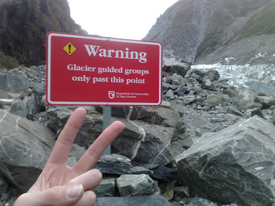
…but then we came to the following sign…

…which we ignored like everyone else did…

And that really was as close as we could
get to it. On the notice boards they print copies of newspaper reports where
people have snuck up to the glacier to touch the ice and the situation ended
very badly indeed. Plus there was no way I was going to get past this rough `n`
ready bloke…

We were due to spend the night at a
campsite in the small village of Haast, a settlement mainly used as a stop-off
point along highway 6. But before we arrived we made our own stop-off at Bruce
Bay, where the custom is to write down your details and a message for the world
on one of the white stones that lie upon the beach.


No comments:
Post a Comment